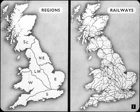
1) It’s always a good thing, when you’re talking about railways, to start off with maps, and that’s why I’m asking you first of all to have a look at these two railway maps of Britain. The one on the right shows the important railway lines, and the one on the left shows the six regions into which British Railways have been divided – the Eastern, London Midland, North Eastern, Scottish, Southern and Western Regions. The right-hand map shows how densely covered with railways this island is, particularly England. Just look at the railways round London, and round Birmingham, Manchester and Glasgow. See how thick they are in the industrial areas of South Wales and Lancashire; and see, too, how many lines connect London with the North of England.
But the railways haven’t always been a unified whole as they are now. Most of you will remember the four companies which existed before the railways were nationalised – the London Midland and Scottish, the London and North Eastern, the Great Western and the Southern Railways. The Great Western was set up in 1922, and the other three in 1923. Thus more than 120 smaller independent companies which had grown up during the preceding years were amalgamated. The names of some of these, too, may be familiar to you – the Midland, for instance, which ran from St. Pancras, London, through Yorkshire to Carlisle; the London and North Western, and the London and South Western. And yet, all the time, the tendency has been towards a unified transport system for Britain, simply because that’s the way the railways function most efficiently. Today, as I have said, all this complicated railway system is unified, and operated in six regions. And now, having dealt with place, let’s deal with time...